
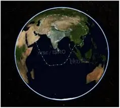
ref:isro
- GPS satellites have transformed positional awareness and navigation, primarily for ship and aircraft surveying, among other applications.
- GPS satellite formerly known as the broadcasting satellite NAVSTAR.
- GPS satellite provides superior accuracy to alternative position location systems like LORAN (Long Range Navigation).
- With an average accuracy of 30 meters, it offers a direct reading of the GPS receiver’s current position.
- Since a GPS receiver only needs to receive signals from four GPS satellites to position itself, an infinite number of GPS receivers can function simultaneously.
- GPs is a locating system with extreme precision.
- The Department of Defense (DOD) in the United States developed and maintains GPS satellites.
- 24 satellites in MEO 20,200 km high orbit, orbital inclination of 550, make up the GPS space segment.
- Four groupings of satellites, known as constellations, are grouped and 600 longitudes apart.
- Half a real day’s orbital period (11 hours and 58 minutes).
- Of the 72 GPS navigation satellites launched by February 2016, some have been decommissioned and are no longer in service.
- A complete constellation requires 24 satellites in operation 95% of the time; the current number is more than this. 33 is the desired number.
Table of Contents
Characteristics of GPS:
1. Free
2. Precise
3. Reliable
4. All weather conditions
5. Anywhere and anytime (almost)
6. Unlimited user capacity
7. Accurate
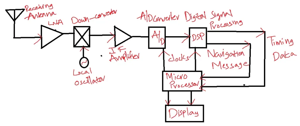
General Working of GPS:
- The GPS master control station (MCS) at Falcon Air Force Base in Colorado Springs, Colorado, is where the US Air Force runs the GPS.
- Every GPS satellite that comes into view is continuously monitored by the MCS and a network of satellite control stations worldwide to establish its orbit.
- The MCS computes atomic clock error, ephemeris data for every satellite, and several more parameters for the navigation message.
- After that, data is sent over an S-band link to a satellite, where MCS continuously measures the distance to every visible satellite every 1.5 seconds and updates navigation messages.
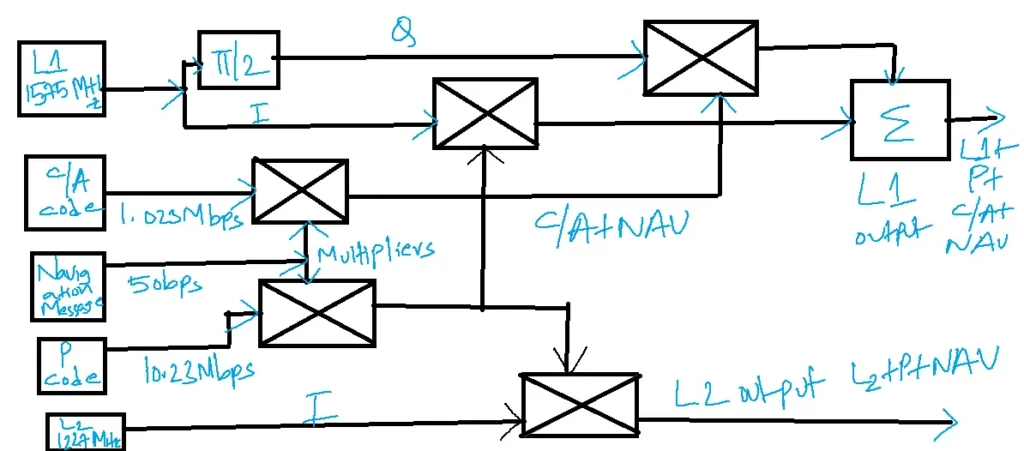
- GPS satellites send out L-band signals that are code-modulated.
- Public C/A (coarse acquisition) code
- Military P (precise) code
- The trilateration approach is used to find the GPS Rx’s position.
- Trilateration is measuring an unknown point’s distance using three known points.
- The time it takes for an RF energy pulse to travel between Tx and Rx can be used to calculate the distance between them, as can the velocity of an electromagnetic wave in free space (3×〖10〗^8m/s).
- Atomic clocks are a precise means of measuring time.
- Atomic clocks, which broadcast bit sequences at a known time, are carried by each GPS satellite.
- The clock in GPS Rx is synchronized with the atomic clock on Sat.
- Rx determines its distance from three visible satellites (Sat) and the corresponding time delay for each satellite’s bit sequence to arrive.
- Utilizing ephemeris data transmitted in navigation messages, Rx determines the position of Sats.
- Four satellites are required instead of just three, with the additional satellite measurement enabling the detection and correction of receiver clock discrepancies.
- Atomic clock: The atomic clock is the most precise timekeeping device ever created, with an accuracy so remarkable that it loses only one second every 15 billion years. By developing an atomic clock that won’t gain or lose a second in 15 billion years, or longer than the universe is thought to be, scientists have broken the record for precise timekeeping.
- GPS satellites use two distinct frequencies for their transmissions: L1 and L2.
- L2 is encrypted, and modulated using a 10.23Mbps pseudorandom (PN) bit sequence, military P-code, and restricted authorization for the general public.
- The L1 carrier has quadrature modulation with 1.023Mbps PN seq, C/A code for public use, and P code.
- P coding with a higher bit rate provides a more precise measurement.
- Selective availability is a procedure that purposefully reduces the C/A code accuracy (SA) – state of emergency
- The GPS System delivers services in two different forms.
- Accurate Positioning System (APCS) – monitor L1 and L2 frequencies for P and C/A codes; military use
- Track C/A code on L1 using Standard Positioning Service (SPS) for the general public
- GPS uses the CDMA multiple access method.
- The European Union and Russia also utilize their satellite navigation systems, Galileo and GLONASS, which offer similar functionality to GPS.
History of GPS:
A satellite navigation system preceded GPS. Transit: The US Navy employed LEO orbits and Dshiftsr shift at the Rx; this resulted in reduced precision. Disadv of Transit: Doppler shift lengthened over time, and there weren’t enough Transit satellites available at all times to continually locate the Rx SARSAT, or Search and Rescue Satellite, which locates Emergency Locator Transmitters (ELTs) on downed aircraft.
When ELTs are crashed, they activate at a specific frequency of 121.5 MHz due to high G-forces.
Trilateration method for position location:
Uses measurements from more than 4 satellites.
Distance = travel time X speed of light.
Determining GPS Position:
- Assume that it is approximately 11,000 kilometers from Satellite A to our location. Right now, we might be anywhere in the designated sphere.
- Let’s now take a second measurement from Satellite B, the second satellite.
- We are now limited to the point where these two spheres connect.
- By obtaining an additional measurement from a third satellite, we can refine our position to only two points.
- These locations represent the convergence points of the first two spheres, forming the third sphere.
- Therefore, we may reduce our position to just two places in space by using a range of three satellites.
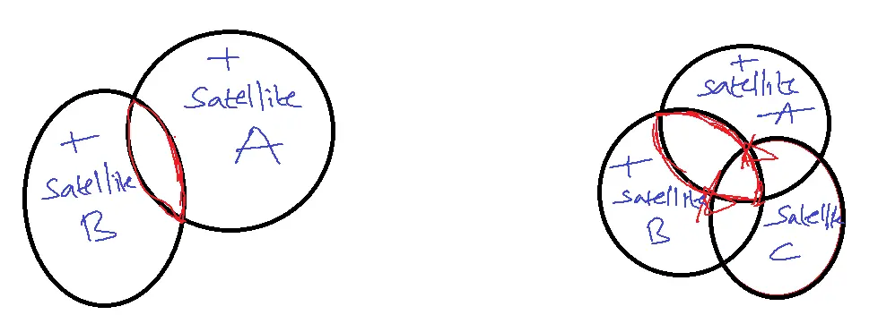
How do we determine which one is where we are?
To ascertain the real point, we could take a fourth measurement from a different satellite OR rule out one of the two points that provide an absurd response.
The absurd point can be too far away from the planet.
But for GPS receivers to pinpoint our exact location, they need a fourth satellite.
GPS Time:
- To obtain a time measurement synchronized with GPS time, add the clock bias value (𝜏), determined during position calculation, to the receiver’s clock time.
- GPS time enables automatic synchronization of all GPS receivers globally. Because of this, every GPS receiver can now tell time more precisely than any other common clock.
- GPS receivers employ a crystal oscillator, which is stable for a few seconds but varies in frequency with temperature and time, leading to errors.
- The GPS satellite uses the fundamental resonance of the cesium/rubidium molecule as a frequency reference to lock a crystal oscillator. It has two cesium clocks and two rubidium clocks (atomic clocks).
GPS Segment:
GPS Segment consists of three types of segments:
1. Space segment- constellation of 24 satellites(21+3)
2. Control Segment – N/W of earth-based control stations
3. User and Equipment.
GPS Satellite Codes:
- The C/A and P codes in the PN sequence are transmitted by GPS satellites.
- In C/A programming 1575.42MHz is the carrier frequency L1, or 154 times the master clock of 10.23MHz.
- The P code covers a period of one millisecond and uses the BPSK modulation clock rate of 1.023MHz 1023 bits.
- 1227.6MHz is the carrier frequency L2, or 120 times the master clock of 10.23MHz.
- The 10.23 MHz clock that governs the 2.35 x 10^14 chip BPSK modulation is initialized weekly.
- Also in phase quadrature with C/A code on the L1 frequency carrier
- Navigation Message:
- The navigation message is packed with information for determining the system’s state, calculating an exact position, and optimizing GPS signal collection.
- The data has a total length of 1500 bits and is broadcast at 50 bits per second using BPSK. sent as a frame from the 30s
- Twenty C/A codes typically make up one Nav message bit.
- At Rx, a 50bps BPSK demodulator that comes after the C/A or P-code correlator extracts the navigation message.
- The narrow BW of the Nav message assures a high S/N ratio and a reduced chance of big mistakes.
- Twenty-five frames comprise the data, and each frame is further partitioned into five sub-frames of 300 bits each.
Almanac Data: The GPS receiver can roughly locate each GPS satellite thanks to the almanac. All almanacs are transmitted by each satellite approximately every 12.5 minutes.
Ephemeris Data: A GPS receiver can listen for ephemeris, or position, data once it has established its approximate location. Every 30 seconds, each satellite transmits this information, which provides the recipient with its exact orbit. Ephemeris data is quite precise, hence its validity is limited to around half an hour.
Signal Generation in a GPS Satellite:
C/A Code Generator:
- All of the C/A codes that GPS satellites transmit are 1023-bit gold codes. G1 and G2, two 1023-bit m-sequences, combine to generate GPS C/A Gold codes.
- Shift registers and feedback taps produce m-seq.
- The bit register produces 1023 bit seq, while the bit shift register generates 2^𝑛−1 bit seq.
- A method is used to generate the C/A code, which contains the Sat identification number, which is a unique code for every Sat. C/A code for the Sat with ID no. 𝑖 is 𝐶_𝑖 (𝑡) 𝐶_𝑖 (𝑡)=𝐺1(𝑡)×𝐺2(𝑡+10𝑖𝑇_𝑐); Clock period for C/A code is 𝑇_𝑐.
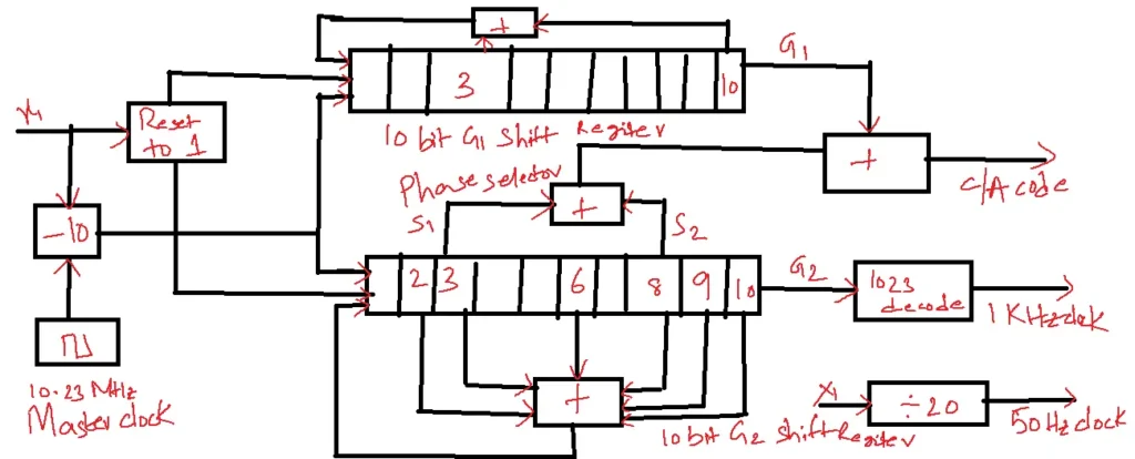
- The equation above can be used to generate a total of 100 gold sequences, but only 37 of those have cross-correlation qualities and are employed in GPS systems.
- GPS receivers rely on low cross-correlation to accurately process signals received from multiple satellites.
GPS Signal Levels:
- Because GPS receiver antennas have to be omnidirectional, their gain is minimal.
- A typical value of 273 K will be utilized for the system noise temperature.
- Generally, GPS antennas consist of quadrupolar helices or circularly polarized patches, with the LNA positioned either below or behind the antenna to prevent lossy cables from raising noise levels.
- GPS satellites contain 10 W transmitters with various helical antennas that offer gain toward the Earth, resulting in EIRP values between 19 and 27 dB.
- The theoretical processing gain for the C/A code broadcast at 1.023 Mbps with a correlation time of 1 ms is 1023, or 30.1 dB. For the P-code, the appropriate processing gain is 40.1 dB.
- Up to ten satellites’ signals can be simultaneously picked up by the GPS receiver. As an interference term, the signals from additional satellites are added to the noise in the Rx.
- The receiver faces the challenge of extracting the relevant information from one GPS satellite among ten visible ones, with the remaining nine producing interfering signals of equal strength.
- Due to their poor cross-correlation with the code from the desired satellite, the signals from interfering satellites are regarded as random noise.
- Typically, an Rx can detect between four to ten GPS satellites, including those at lower elevation angles. Nine inter-satellites is the worst-case scenario.
How accurate is GPS?
- Depending on a few factors
- Measurement time
- The receiver’s design
- Technically referred to as post-processing relative positions of satellites or PDOP
Differential GPS:
- Leveraging differential GPS (DGPS) techniques can significantly improve the accuracy of GPS measurements.
- Differential GPS requires a stationary, reference GPS receiver located at a fixed position.
- In simpler DGPS implementations, a reference GPS receiver at a precisely known location continuously calculates its position using the GPS C/A code.
- The first GPS receiver receives the differences in x, y, and z after the computed (x, y, and z) location is compared to the station’s known location through radio telemetry.
- The precision of C/A code position measurements can be enhanced by an order of magnitude, from approximately 100 meters to around 10 meters.
- This technique only calculates position correctly if the two stations are close to each other and use the same four satellites.
- With advanced DGPS, the precision of a C/A code measurement can be raised to 5 m for receivers located within 10 km and 10 m for receivers situated within 500 km of the reference station.
- Differential phase, sometimes known as kinematic DGPS, is a technique used to detect Receiver motions at the centimeter level in GPS transmissions. It does this by utilizing the relative phases of the various signals.
Methods of Data Collection:
Three approaches to positioning
1. 10–20 meters of autonomy.
2. Difference: 2–5 meters.
3. Measurement Unit: Centimetres
Several incredible uses for GPS:
1. Earth Tides
2. Measuring subsidence
3. Track the moving Earth
4. Post-glacial Rebound.
5. Geocaching
6. Emergency Rescue
7. Post-glacial rebound, often referred to as isostatic rebound or crustal rebound, is the rising of land masses depressed by the immense weight of ice sheets during the previous glacial epoch, known as isostatic depression.
8. Geocaching is an outdoor leisure game where participants conceal and seek containers, sometimes known as “geocaches” or “caches,” in precise sites marked by coordinates all over the world using a Global Positioning System (GPS) receiver or mobile device and other navigational tools.
Common Use of GPS:
1. GIS Data Collection and Mapping
2. Navigation
3. Recreation
Applications of GPS Satellite
- Navigation and mapping: precise positioning for vehicles and individuals, enabling route planning and location-based services.
- Surveying and mapping: accurate land measurements and map creation for construction, agriculture, and urban planning.
- Timing and synchronization: highly accurate time signals for telecommunications, power grids, and financial markets.
- Emergency response and disaster management: locating individuals, tracking search and rescue teams, and assessing natural disaster impact.
- Agriculture and precision farming: GPS-guided machinery for optimizing fertilizer and pesticide application, monitoring crop health, and improving efficiency.
Related FAQs
1. What is GPS and how do GPS satellites work?
- GPS (Global Positioning System) is a network of satellites orbiting Earth that transmit signals to GPS receivers on the ground.
- These receivers use the signals to calculate their precise location based on trilateration (measuring distances from multiple satellites).
2. How many GPS satellites are there and who operates them?
- The United States Space Force currently operates a constellation of over 30 active GPS satellites orbiting Earth.
- The constellation is designed to ensure that at least four satellites are visible from almost any point on Earth at any given time.
3. What are the main uses of GPS?
- GPS is used for navigation (cars, airplanes, ships), surveying, mapping, timing (for telecommunication networks, financial transactions), and tracking (assets, people, wildlife).
- It also plays a crucial role in emergency response and disaster management.
4. Is GPS free to use?
- Correct, GPS is a publicly available service, funded by the U.S. government, and accessible to civilians at no cost.
- There are no subscription fees or usage charges for accessing GPS signals.
5. What is the accuracy of GPS?
- Several factors can impact GPS accuracy, such as atmospheric conditions, obstructions that block signals, and the receiver’s quality.
- In general, civilian GPS provides accuracy within a few meters. More advanced systems, like differential GPS (DGPS), can achieve even higher accuracy.